
CURRENT PROJECTS
- Antenna Multipath Calibration System
- Atlantic Mediterranean Interdisciplinary GPS
- Atmospheric Structure and Dynamics
- Basin and Range Geodetic Network
- BIFROST Fennoscandian GPS Network
- EPS 206
- Project ATLAS
- Sea Level
- Western U.S. Cordillera Deformation Field
LINKS
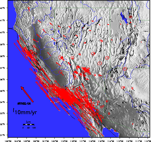
An Introduction to the Western U.S. Cordillera (WUSC) Velocity Field
Data sets used to determine the WUSC velocity field.
WUSC velocity solutions are obtained from analyses of Global Positioning System (GPS) and very long baseline interferometry (VLBI) observations.
The raw GPS data (RINEX format) that were used to create the most recent WUSC velocity solution (shown below) can be obtained from:
The University NAVSTAR Consortium (UNAVCO)
Scripps Orbit and Permanent Array Center (SOPAC)
The Southern California Earthquake Center (SCEC)
The VLBI data that were used to create the WUSC velocity solution can be obtained from:
Goddard Space Flight Center (GSFC)
GPS data reduction.
Analyses of the raw GPS data were performed by SOPAC, Massachusetts Institute of Technology (MIT), and the Smithsonian Astrophysical Observatory (SAO). (The STRC data sets analyzed at MIT form part of the SCEC data set. We did not include all of the sites from the particularly dense networks in southern California (see, for example, the SCEC Horizontal Deformation Velocity Map.)
All GPS data were reduced using the GAMIT software [King and Bock, 1997]. Data were processed in batches of one day. The products of these analyses include daily estimates for station positions, Earth orientation parameters, and GPS satellite orbital parameters. Separate (daily) sets of parameter estimates were obtained for each network.
We combined those daily parameter estimate sets having a common reference epoch using the GLOBK software [Herring, 1997]. The products of these daily combinations are self-consistent sets of station position and Earth orientation parameter estimates for all of the stations in all of the networks represented in the individual parameter estimate sets. That is, after combination, all parameter estimates refer to a common, homogeneous reference frame. Combined orbital parameter estimates are not written to the solution files, although the orbital information is included in the combination.
GPS campaigns (STRC, YUCC)) were treated slightly differently from the daily continuous GPS combinations. For the GPS campagins, all sessions comprising an experiment were stacked to form multiple epoch combinations.
The general ``distributed processing'' strategy that we employ is discussed in several papers. The interested reader should refer to Blewitt et al. [1993], Feigl et al. [1993] (Appendix A), Dong et al. [1998] and references therein. Bennett et al. [1999] describes our application of this strategy to the WUSC data set.
VLBI data reduction.
Please refer to the Goddard Space Flight Center (GSFC) Geodetic VLBI web site for more information about the NASA Space Geodesy Program and GSFC data analyses [Ma and Ryan, 1997]. VLBI SINEX files containing VLBI station position and Earth orientation parameter estimates are available from this web site.
Velocity field estimation.
We used the VLBI and combined GPS parameter estimate sets (SINEX files) to estimate a single self-consistent set of site velocities. We used the GLOBK software [Herring, 1998] to determine these velocity estimates. The product of this analysis was a set of velocity estimates for a large number of globally distributed GPS and VLBI stations. There are 325 distinct velocity estimates in WUSC Solution 001, for example. We expect that both the number of stations and the precision of our estimates will increase with future releases of the WUSC solution.
We excluded from our solution all site position data whose evolution was obviously not well described by a constant velocity, allowing for discrete offsets due to earthquakes, antenna changes, etc. We made no attempt to tie the positions of collocated stations. Instead, we constrained sites within 1 km of one another to have the same velocity, effectively tying the velocities of GPS and VLBI antennas located at the same site. We make no distinction between velocities derived from VLBI, GPS, or combined VLBI and GPS data.
The variance-covariance matrix of the velocity solution has not been rescaled. The variance-covariance matrix is based on the least-squares propagation of scaled observation errors and is intended to represent the statistical uncertainty due to errors in the space geodetic measurements. It does not reflect potential deficiencies in the constant velocity model that we adopted to estimate site velocities. Of particular recent concern, for example, is the potential for site specific monument instability, which is suspected to be a non-negligible source of unmodeled signal for many geodetic monuments in California [e.g., Langbein and Johnson, 1997; Zhang et al., 1997]. This is an area of current research.
More to come. Please stay tuned...
REFERENCES

Bennett, R.A., W. Rodi, and R.E. Reilinger, GPS Constraints
  on Fault Slip Rates in Southern California and Northern Baja,
  Mexico, Journ. Geophys. Res., 101, 21,943-21,960, 1996.

Bennett, R.A., J.L. Davis, P. Elosegui, B.P. Wernicke, J.K.
  Snow, M.J. Abolins, M.A. House, G. L. Stirewalt, and D. A.
  Ferrill, Global Positioning System Constraints on Fault Slip
  Rates in the Death Valley Region, California and Nevada,
  Geophys. Res. Lett., 24, 3073-3076, 1997.

Bennett, R.A., B.P. Wernicke, and J.L. Davis, Continuous GPS
  measurements of contemporary deformation across the northern
  Basin and Range province, Geophys. Res. Lett., 25, 563-566,
  1998.

Bennett, R.A., J.L. Davis, and B.P. Wernicke, The Present-day
  pattern of western U.S. Cordillera deformation, Geology, 27,
  371-374, 1999.

Beutler, G., I.I. Mueller, R.E. Neilan, The International GPS
  Service for Geodynamics: development and start of official
  service on January 1, 1994, Bull. Geod., 68, 39--70, 1994.

Blewitt, G, Y. Bock, G. Gendt, Regional clusters and distributed
  processing.  Proceeding of the IGS Analysis Center Workshop,
  Ottawa, Oct 12-14, 1993.

Bock, Y., S. Wdowinski, P. Fang, J. Zhang, J. Behr, J. Genrich,
  S. Williams, D. Agnew, F. Wyatt, H. Johnson, S. Marquez, K.
  Hudnut, R. King, T. Herring, K. Stark, S. Dinardo, W. Young,
  D. Jackson, and W. Gurtner, Southern California Permanent GPS
  Geodetic Array: Continuous measurements of regional
  deformation, J. Geophys. Res., 1997.

Boucher, C., Z. Altamimi, M. Feissel, P. Sillard, Results and
  analysis of the ITRF94, IERS Tech. Note 20, Cent. Bur., Obs.
  de Paris, Paris, France, 1996.

Dong, D., T.A. Herring, and R.W. King, Estimating crustal
  deformation from a combination of terrestrial and space-based
  data, J. Geod., 1998.

Feigl, K.L., D.C. Agnew, Y. Bock, D. Dong, A. Donnellan,
  B.H. Hager, T.A.  Herring,  D.D. Jackson, T.H. Jordan, R.W.
  King, S. Larsen, K.M. Larson, M.H. Murray, Z. Shen, and F.H.
  Webb, Space geodetic measurement of crustal deformation in
  central and southern California, 1984-1992, J. Geophys. Res.
  98, 21,677-21712, 1993.

Herring, T.A., GLOBK: Global Kalman Filter VLBI and GPS analysis
  program, v.4.1, Mass. Inst. of Technol., Cambridge, 1998.

King, N.E., J.L. Svarc, E.B. Fogleman, W.K. Gross, K.W. Clark,
  G.D. Hamilton, C.H. Stiffler, and J.M. Sutton, Continuous GPS
  observation across the Hayward fault, California, 1991-1994,
  J. Geophys. Res., 100, 20271-20284, 1995.

King, R.W. and Y. Bock, Documentation for the MIT GPS analysis
  software: GAMIT, Mass. Inst. of Technol., Cambridge, 1998.

Langbein, J. and H. Johnson, Correlated errors in geodetic time
  series: implications for time-dependent deformation,
  J. Geophys. Res., 102, 591--603, 1997.

Ma, C., and J.W. Ryan, "NASA Space Geodesy Program -- GSFC DATA
  Analysis -- 1997, VLBI Geodetic Results 1979-1997", August,
  1997.

Shen, Z., D. Dong, T. Herring, K. Hudnut, D. Jackson, R. King,
  S. McClusky, L. Sung, Crustal deformation measured in southern
  California, EOS Trans. AGU, v. 78, p. 477, 1997.

Strange, W. E., A national spatial data system framework
  continuously operating GPS reference stations, Proceedings of
  the First Federal Geographic Technology Conference. GIS in
  Government, USA GIS World Fort Collins, CO, USA, 1, 1994.

Zhang, J., Y. Bock, H. Johnson, P. Fang, S. Williams, J.
  Genrich, S. Wdowinski, J. Behr, J., Southern California
  Permanent GPS Geodetic Array: error analysis of daily position
  estimates and site velocities, Journ. Geophys. Res., 102,
  18,035-18,055, 1997.

Table 1. Geodetic networks used to estimate WUSC velocity field.
----------------------------------------------------------------
Network | Network  | Data  | Data     | Sample
Name    | Location | Type  | Location | References
----------------------------------------------------------------
BARD      No. CA     CGPS    SOPAC      King et al. [1995]
CORS      U.S.       CGPS    SOPAC      Strange [1994]
IGS       Global     CGPS    SOPAC      Beutler et al. [1994]
NBAR      No. B&R    CGPS    UNAVCO     Bennett et al. [1998]
SCIGN     So. CA     CGPS    SOPAC      Bock et al. [1997]
STRC      So. CA     FGPS    MIT/SCEC   Bennett et al. [1996]
VLBI      Global     VLBI    GSFC       Ma and Ryan [1997]
YUCC      ECSZ       FGPS    UNAVCO     Bennett et al. [1997]
----------------------------------------------------------------

Table 2. Analyses of the raw GPS and VLBI data
used to estimate the WUSC velocity field.
-----------------------------------------------
Network | Analysis    | Time         | Analysis
Name    | Software    | Span         | Group
-----------------------------------------------
BARD      GAMIT       1996.6-present  SOPAC
CORS      GAMIT       1996.6-present  SOPAC
IGS       GAMIT       1996.6-present  SOPAC
NBAR      GAMIT       1996.6-present  SAO
SCIGN     GAMIT       1996.6-present  SOPAC
STRC      GAMIT       1988.1-1997.2   MIT
VLBI      CALC/SOLVE  1979.7-1998.4   GSFC
YUCC      GAMIT       1991.8-1997.9   SAO
-----------------------------------------------
For further information contact:
WUSC Questions
Harvard-Smithsonian Center for Astrophysics
60 Garden St, MS 42
Cambridge, MA 02138-1516
(617) 496-7811
![]()
For questions or comments on web site contact: Geodesy Webmaster
Document URL: lweb.cfa.harvard.edu/space_geodesy/WUSC/introduction.html
Last Modified: Friday, 18-Jul-2003 14:12:03 EDT