Atmospheric trace gases, such as ozone, carbon dioxide, and methane, have significant impacts on human health and the climate; these are the three most important greenhouse gases from human activities, and ground level ozone is the most prevalent air pollutant in the United States. Despite their importance societally and scientifically, the precise abundances, sources, and effects of these trace gases remain uncertain.
My overarching objective is to develop methods to combine the available information from models and observations of atmospheric trace gases and in doing so to both improve understanding of atmospheric chemistry and advance the techniques that are applied to the use of current and future atmospheric measurements.
TEMPO: (Tropospheric Emissions: Monitoring of Pollution)
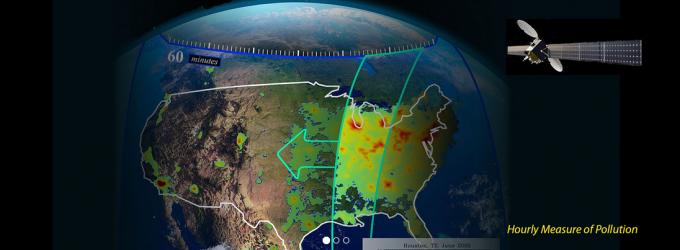
I am a member of the TEMPO science team and have been heavily involved in its planning and development for the past decade. TEMPO will measure atmospheric pollution for North America from space using ultraviolet and visible spectroscopy. It was selected in 2012 by NASA as the first Earth Venture Instrument, for launch between 2018 and 2021. TEMPO will provide a tropospheric measurement suite that includes the key elements of tropospheric air pollution chemistry, as well as contributing to carbon cycle knowledge. Measurements are made hourly from geostationary (GEO) orbit, to capture the high variability present in the diurnal cycle of emissions and chemistry that are unobservable from current low-Earth orbit (LEO) satellites that measure once per day. The small product spatial footprint resolves pollution sources at sub-urban scale. Together, this temporal and spatial resolution improves emission inventories, monitors population exposure, and enables effective emission-control strategies.
The science team recently wrote the TEMPO mission paper for which I was the lead author: Zoogman et al. 2016b (proof).
Surface Reflectance in the Visible
TEMPO observations in the weak visible ozone bands takes advantage of the relative transparency of the atmosphere in the visible to achieve sensitivity to near-surface ozone. However, due to the weakness of these ozone absorption features this measurement is more sensitive to errors in visible surface reflectance, which is highly variable. I utilized reflectance measurements of individual plant, man-made, and other surface types to calculate the primary modes of variability of visible surface reflectance at a spectral resolution comparable to than that of TEMPO (0.6 nm). Using satellite (MODIS) surface products and our derived primary modes I constructed a high spatial resolution climatology of wavelength-dependent surface reflectance over all viewing scenes and geometries. This work is being used to enable TEMPO air quality measurements.
For more information see Zoogman et al. 2016a.
Optimization of Trace Gas Retrievals
Geostationary measurements from TEMPO will be a powerful new resource, but will also be an amount of data far more vast than previously processed by atmospheric chemistry studies. In order to facilitate retrieval of trace gas columns and profiles from TEMPO spectra I performed an evaluation of different numerical algorithms for precision and computational cost. I found that a Levenberg-Marquardt scheme provided the lowest cost while retaining the desired precision. A linearized algorithm was considerably faster but introduced large errors for some spectra. A generic Non-Linear Least Squares approach was the slowest. I am currently working on implementation of the numerical algorithm to be used for TEMPO operations.
Geostationary Observations of Ozone Air Quality -- PhD Research
My thesis investigated the benefit of an instrument in geostationary orbit for observing near surface ozone using Observing System Simulation Experiments (OSSEs). This work lead to the funding and development of the TEMPO mission.
Ozone Air Quality Measurement Requirements for a Geostationary Satellite Mission
I performed an Observing System Simulation Experiment (OSSE) to test the ability of geostationary satellite measurements of ozone in different spectral regions to constrain surface ozone concentrations through data assimilation. This was done to define the measurement requirements for geostationary observations of ozone air quality. Instruments using different spectral combinations of UV (290-340 nm), Vis (560-620 nm), and thermal IR (TIR, 9.6 μm) were analyzed. This work highlighted the desirability of a UV+Vis geostationary instrument, which became TEMPO.
For more information see Zoogman et al. 2011.
Improved monitoring of surface ozone air quality by joint assimilation of geostationary satellite observations of ozone and CO
I developed an innovative approach to assimilating ozone air quality from space using observations of carbon monoxide as an additional error correlation constraint in a joint ozone-CO assimilation. Boundary layer sensitivity is easier to achieve for satellite observations of CO than for satellite observations of ozone. A paired-model analysis of ozone-CO error correlations in the boundary layer over North America in summer indicates positive error correlations in continental outflow but negative regional-scale error correlations over land, the latter reflecting opposite sensitivities of ozone and CO to boundary layer depth. There is substantial benefit from joint ozone-CO data assimilation in informing US ozone air quality if the instrument sensitivity for CO in the boundary layer is greater than that for ozone.
For more information see Zoogman et al. 2014a.
Monitoring high-ozone events in the US Intermountain West using TEMPO geostationary satellite observations
I examined the ability of the future geostationary satellite TEMPO to monitor and attribute air quality exceedances in the Intermountain West. Tracking and attributing sources of ozone pollution is a critical scientific and health issue. We found that assimilation of surface measurements does not capture elevated levels due to lack of information in the free troposphere and sparse spatial coverage. Assimilation of TEMPO geostationary observations greatly improves the assimilated model’s ability to reproduce ozone exceedances and attribute them to background influence.

above Figure: Combining TEMPO observations into a chemical model of the atmosphere (GEOS-Chem) recaptures the structure of a stratospheric intrusion
For more information see Zoogman et al. 2014b.
Atmosperic gases from Fires
Trace gas emissions from biomass burning can vary greatly both regionally and from event to event, but our current scientific understanding is unable to fully explain this variability. The large uncertainty in ozone formation resulting from fire emissions has posed a great challenge for assessing fire impacts on air quality and atmospheric composition. Satellite observations offer a powerful tool to observe biomass burning events by providing observations globally over a range of environmental conditions that effect emissions. I have investigated the seasonal relationship of biomass burning enhancements of these trace gases derived from observations over tropical regions.
I have found that the emissions and chemistry is dependent on the burned land type and will present our current hypotheses for the spatial variation of this ratio in the tropics. Furthermore, in individual case studies I am investigating how these observations can inform our knowledge of the secondary formation of ozone.