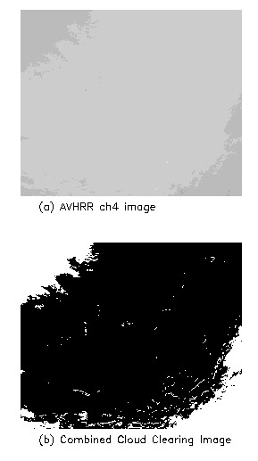
The image used in this lab is a NOAA-14 AVHRR
nighttime land image [Figure 1a] in South Africa. Most of the area is under clear
conditions. cloud clearing was first performedto get clear pixels. Gross IR test,
spatial threshold test, fog/low-status cloud test, medium/high cloud test, and cirrus
cloud test are used in order. Actually, gross IR test is pretty enough to detect all the
cloud-contaminated pixels. The coverage of clear pixels is about 85% [Figure 1b].
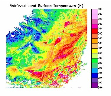
The split-window method (Franca and Cracknell, 1994)
is used to retrieve the land surface temperature. The retrieved temperature is calculated
based on the equation (12): Ts=T4+A*(T4-T5)+B. The emissivity is assumed as 0.97 in
channel 4, and 0.96 in channel 5. Since this image is located in mid-latitude regions,
mid-latitude winter profiles are used. According to table 2 in this paper, A is 1.67 and B
is 0.80. The surface temperature is calculated for all the clear pixels, and is plotted in
the attached image [Figure 2].
Figure 2. Retrieved temperature for the given image.
Atmospheric effects can be corrected using discrete
radiative transfer models such as SBDART code with the knowledge of atmospheric state and
surface emissivity. For a given temperature, the emitted radiance can be known according
to Planck function and surface emissivity. Input the atmospheric temperature, water vapor
profiles and other auxiliary data into SBDART, we can calculate the emitted radiance at
the top of atmosphere, i.e. the radiance received by satellite. In practice, we can obtain
atmospheric profiles from either radiosoundings or assume some atmospheric profiles. Then
we can use discrete radiative transfer models to construct a look-up table of surface
temperature vs. emitted radiance at TOA for certain view geometry. For a certain measured
radiance, we can easily find the corresponding surface temperature. Multi-channel
measurements can be used to exclude the effects of uncertainty in the used auxiliary data.