 |
An Introduction to Project ATLAS The Global Positioning System (GPS) Experiment 1: The Global Mapping
Experiment Experiment 2: The Community Mapping
Experiment |
The Observation Phase (Performed over the period May 11-25, 1999. Classroom time may vary.)
What You Need to Do Before the Observation Phase
Before you perform the Community Mapping Experiment Observation Phase, you must have completed the Design Phase. If you have completed the Design Phase, you will have a list of the locations in your community that you will map. You must also have decided upon a strategy for performing the Community Mapping Experiment Observation Phase. Finally, you must have completed the Global Mapping Experiment and determined your Reference Location.
Each Location on the List Must be Visited
Each location on the list of locations must be visited, one at a time. At each site, turn on the GPS receiver and follow the procedures for determining the location (latitude and longitude) described in the Global Mapping Experiment instructions. For each location visited, fill out a Community Mapping Experiment Field Log.
After all the locations are mapped, you should have your class (as an assignment, or perhaps as a classroom exercise) fill out the Community Mapping Experiment Summary Form.
The locations must be measured before May 24, 1999. (See Table 1 of Introduction to Project ATLAS.)
E-mail the Results to Your Colleagues
Using the "Summary of Locations" on the Community Mapping Experiment Summary Form, send an e-mail before May 28, 1999 to the ATLAS e-mail site (atlas@cfa.harvard.edu). The "Subject" of the e-mail should be "Map of XXX" where "XXX" is the name of your city or town. The body of e-mail should have the following format:
Name of School(s)
City and country
e-mail address
Name of Location #1 Latitude #1 Longitude #1
Name of Location #2 Latitude #2 Longitude #2
And so on…
Note that the Latitudes and Longitudes must be in Map Coordinates, found in the fourth and seventh columns of the "Summary of Locations" table on the Community Mapping Experiment Summary Form. The method for converting Latitude and Longitude to Map Coordinates is described in Community Mapping Experiment: How to Convert Latitude and Longitude to Map Coordinates.
Why do we convert to Map Coordinates?
Map coordinates are distinctly different, but related, to standard latitude and longitude. Map coordinates tell you where you are locally, within your own city or town, for example. Latitude and longitude tell you where your town is on the Earth. Map Coordinates are similar to directions one might give to find someplace in town. "Drive 5 km north and 3 km west," you might say. But if you’re driving hundreds or even thousands of kilometers, a more global view is required.
Plot Phase (Classroom time may vary)
At some point, you will have received one or more e-mails giving the locations of landmarks in other communities around the world. You need to plot these up to see what the communities look like. As an example, let’s say that you have received an e-mail with the following information:
Subject: Map of Cambridge
St. Peter’s Middle School
Cambridge, Massachusetts, U.S.A
ourclass@stpeter.mass.edu
Fenway Park -5.372 6.356
Harvard Square -2.635 -3.392
City Hall 4.364 8.384
Boston Common -7.373 -7.352
Belmont Center 2.356 -8.263
First, you’ll need the graph paper. Near the center of a sheet (one sheet per city), make a dot:

This "dot" represents your school, the reference site. Now draw the Latitude and Longitude axes through the dot and label them:

Now, each line in the file is a set of
coordinates. For example, the coordinates of "Fenway Park" are Latitude = —5.372, Longitude = 6.356. "Longitude = 6.356" means the "dot" for "Fenway Park" will be 6.3 squares to the right of the center. "Latitude = —5.372" means the "dot" for "Fenway Park" will be 5.4 squares down from the center. (Down because of the "minus sign.") Thus, put a dot for "Fenway Park" 6.3 squares to the right and 5.4 squares down from the center:
Now do this for the rest of the landmarks. Your final map should look like:
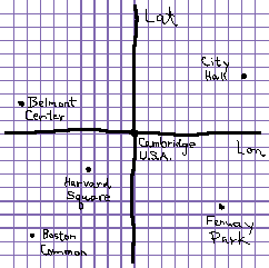
This is the St. Peter’s Middle School map of Cambridge, Massachusetts, U.S.A! Notice we’ve labelled the Reference Location with the name of the city. It’s best to do this last after you know where the other points will go.
The students should be prompted to think about the map they are making. Which of these landmarks do they think are government buildings? Public areas? Places for sports? Is "Fenway Park" a park with trees and grass or a sports stadium? Maybe the students will want to e-mail the class who provided the data and ask these questions.
Space Geodesy Group
Harvard-Smithsonian Center for Astrophysics
60 Garden St, MS 42
Cambridge, MA 02138-1516